1.- INTRODUCTION TO THE NAZCA LINES MAP
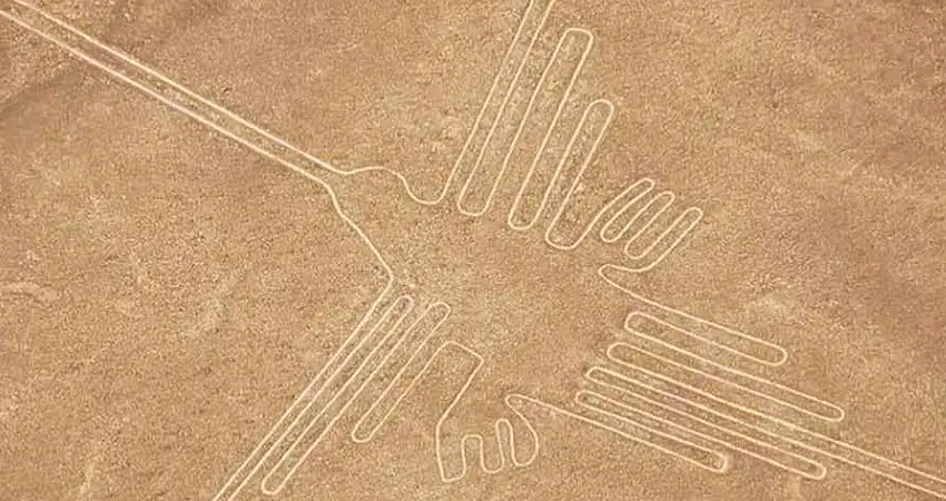
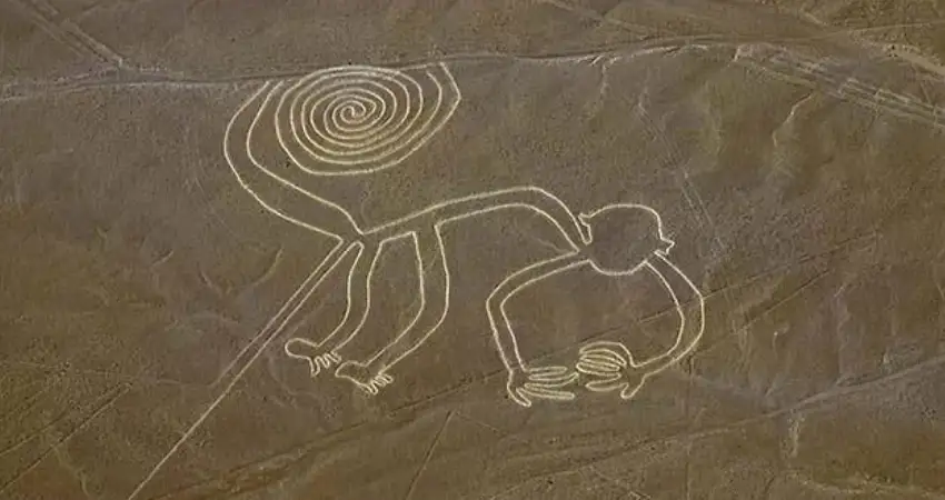
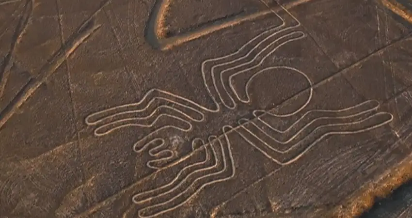
Something that people do not know about the Nazca Lines Location Map is that it is inside an immense arid desert, in its interior are the set of unique geoglyphs in its type that until today its origin and even more its purpose is unknown, what they do know is that its antiquity goes from 500 years before Christ to 500 years after Christ and they present clear images on the desert floor that there is, the formed images that are shown in a clear way represent animals like the hummingbird, spiders, monkeys, fish, sharks, lizards, plants and people.
There are multiple theories about the origin of the geoglyphs and there is everything in the Nazca Lines map, from representations of astronomical calendars to crazier ideas like a landing port for extraterrestrials, however the existence of this place undoubtedly represents an icon of cultural identity inherited by the ancient cultures of Peru. The Map Nazca Lines is commonly used by travelers arriving here for the first time to find their way around all the important places you can visit.
When you look at the Nazca Lines map you can see at a glance how all the geoglyphs have a curious alignment that is directly related to theories linked to astronomy and access route to points of origin of water that in the Andean world is known as “puquios” where the water comes from the center of the earth, this is the theory most accepted by specialists also taking into account the Nazca Lines location map where you can see that the surrounding space is completely arid.
2.- OVERVIEW OF THE NAZCA LINES MAP
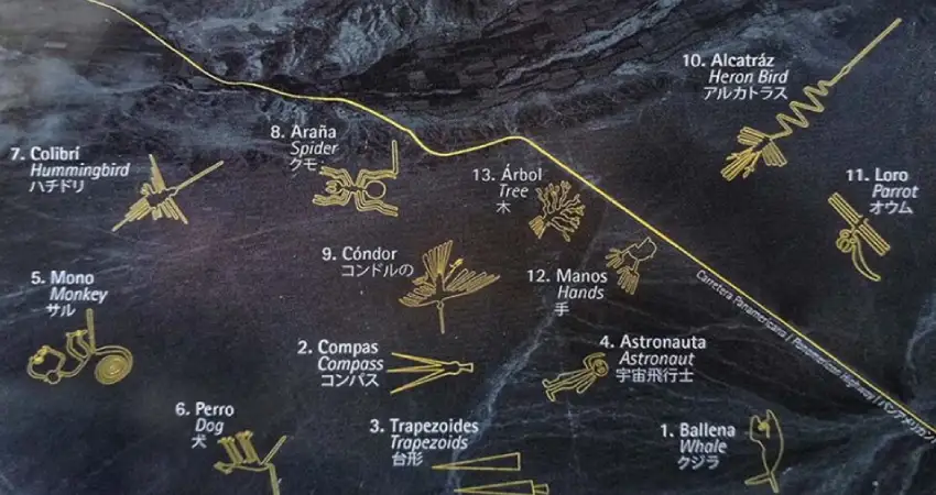
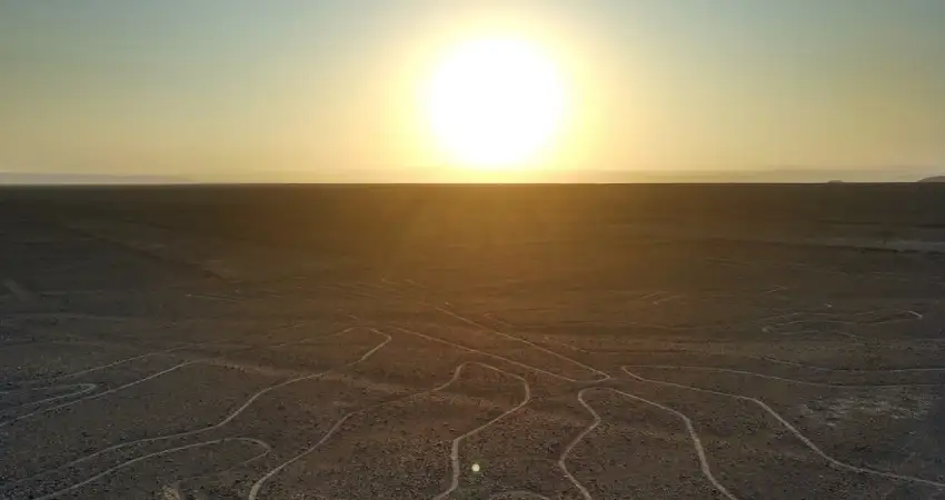
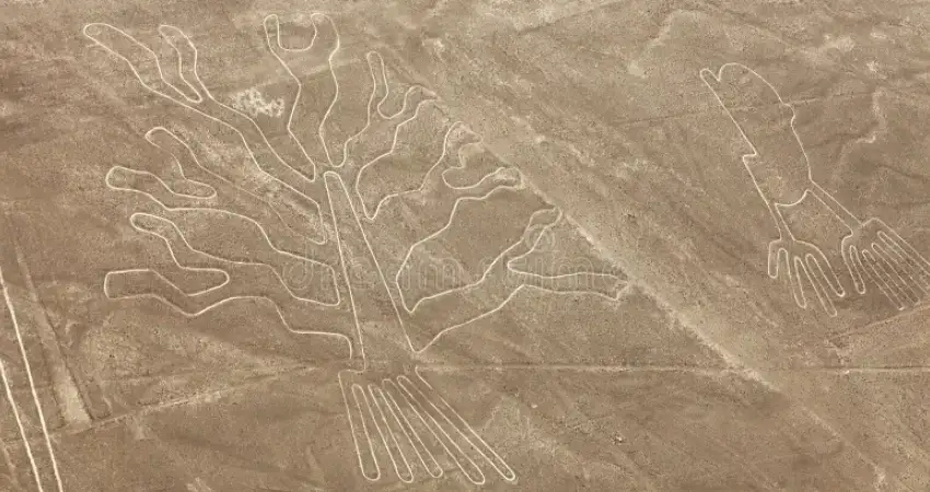
It is common to see inside the Nazca Lines map as many of the geoglyphs are scattered in the vast desert landscape, showing multiple and varied figures from simple lines to zoomorphic representations among the most popular are the monkey, hummingbird, spider, bird, tree and hands. Its elaboration was made by making small excavations leaving exposed the clear earth of the base which makes the figure visible to the naked eye, although to be able to appreciate it in the best way it is necessary to fly over it in a small plane.
3.- NAZCA LINES MAP DETAILS
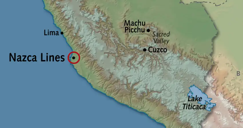
At first glance, the Nazca Lines map is located in the desertic landscape of Nazca, within the Nazca pampas. The set of geoglyphs is located in the coastal region of Peru, 400 km south of the capital city of Lima and covers an area of more than 450 square km. When a traveler is at ground level can differentiate some of the lines at a glance but will not have a clear picture because to appreciate it must fly over in a plane, another way to appreciate what contains the Nazca Lines map is the watchtower from where it shows a high point and is appreciated from a different perspective all the geoglyphs, of course this does not compare at all to the overflight tour.
4.- HOW TO GET TO NAZCA LINES MAP
The first thing to do is to take a tourist bus from Lima to the city of Ica, where you can make a short stop to enjoy the surrounding attractions such as vineyards or take a little time to relax in the natural oasis of Huacachina. Then you can continue to the city of Nazca where you will find the aerodrome, from here is where all the overflight tours start and also your next adventure.
5.- NAZCA LINES MAP PRESERVATION
In spite of the time this mysterious place has remained intact even defying the nature but it leaves the doubt of how these drawings of great dimension are maintained with the intense presence of winds, rains and others. Well the answer is quite simple, the base of the geoglyphs are made of stone and because the climate is mostly dry there is no erosion so it is a suitable environment for these are maintained.
6.- NOTABLE GEOGLYPHS AND THEIR LOCATIONS
Of all the geometric shapes and images that are presented within the Map Nazca Lines the most iconic are:
6.1.- The Colibri
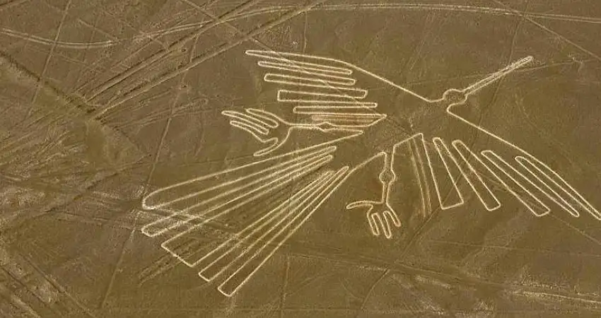
This is one of the main figures found inside the Nazca Lines map, the particularity of this figure is the 96 meters of size that is located in the pampas of Nazca (kilometer 420 of the South Panamerican Highway). This figure is shown with its wings extended which characterizes its symmetry at first sight. According to the Andean belief, the hummingbird represents a deity related to water since they are always seen near water sources.
6.2.- The monkey
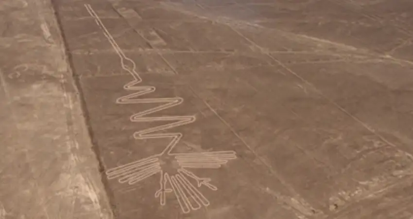
Also found near the Nazca pampas (Kilometer 418 of the Panamericana Sur), by far the figure of the monkey is the second most popular figure in the Nazca Lines map, with more than 135 meters in size it forms the image of a monkey with a spiral tail curled. It is a very mysterious image due to the fine finishes that it has, in addition to the fact that in one of the hands it has five fingers, which gives a direct relationship with humans. Among many theories, this is the one that is mainly linked to astronomy and the Andean calendar.
6.3.- The spider
This is one of the smallest images in the Nazca Lines map, it is only 46 meters in size, it is also located in the Pampa de Nazca (kilometer 420 of the Panamericana Sur). What stands out is how the figure of the spider shows long and thin legs very well finished with precision, according to the theories around this image that it is related to Andean astronomy, symbolizing fertility.
| “Sometimes you have to travel far to get back home.” |
6.4.- The Astronaut
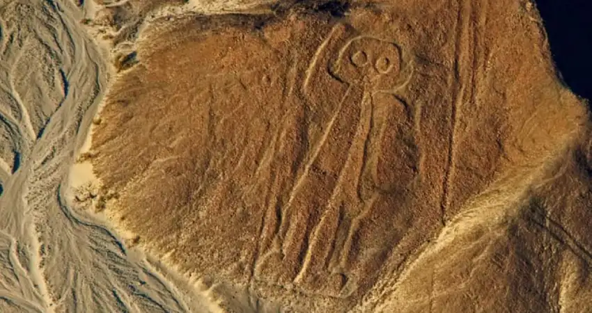
It is also popularly known as the owl man, what makes this image stand out from the rest found inside the Nazca Lines map is that it is the only figure with anthropomorphic representation simulating a human person. Its size is also quite small measuring around 32 meters and it is the one located in a high area of Palpa. Due to its peculiar design this figure has been directly related to beings from other worlds giving the theory that the whole set of geoglyphs was used as an extraterrestrial port, although of course other people give another representation simulating an Andean priest of ancient cultures.
6.5.- The dog
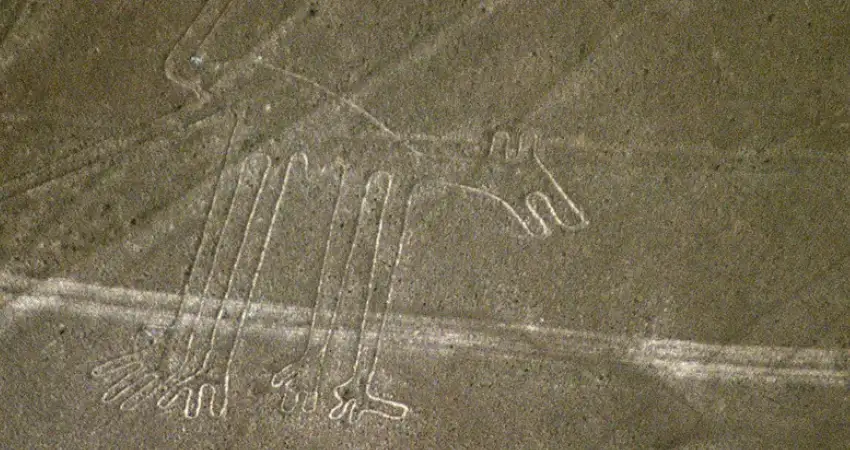
Another of the most outstanding figures of the set of images of the Nazca Lines map. It has a little more than 50 m of size having within its design a canine figure with a silhouette of spiral tail simulating to have the tongue out. It is also located in the pampa of Nazca (kilometer 418 of the Panamericana Sur), quite close to the geoglyphs of the monkey and the hummingbird. Although its exact meaning is not known, it is known that in the Andean cosmogony, the dog represents protection and at the same time the hunting activity.
6.6.- The Condor
It is considered one of the largest geoglyphs of the entire Nazca Pampas (kilometer 424 of the South Pan-American Highway). Its silhouette forms a condor with outstretched wings that today we know as the icon of the Andes and is considered one of the most important sacred birds of the culture and for some cultures its presence was related to the interpretation of the will of the gods, according to this belief the condor is related to the condor as a spiritual and religious connection between the world of heaven and the earthly world.
UNIQUE IN THE WORLD
“The Nazca Lines have the category of World Heritage of Humanity established by UNESCO, besides being an icon of cultural identity for many Peruvians. I assure you that enjoying the panoramic view in the overflight of the geoglyphs is something unique in life..
6.7.- The Alcatraz
The particularity of this geoglyph is its incredible size, it is more than 300 m long and it is also located within the Nazca Pampa (kilometer 429 of the Panamerican Highway South). Although its shape is still debatable, many people see it as a gannet while others interpret it as a flamingo and thanks to its incredible size, it is considered one of the largest figures in the Map Nazca Lines.
6.8.- The Hands
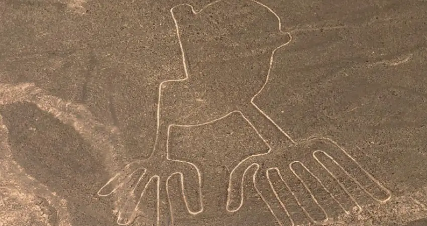
Catalogued as one of the simplest but at the same time most representative, it is found quite close to the image of the tree. In the extensive pampa of Nazca (kilometer 421 of the South Pan-American Highway) it shows a pair of hands with a curious detail, one of these has five fingers while the other only has four. This has been enough for many investigators to relate it also with the presence of beings from another world, this image is one of the easiest to appreciate from the observation tower.
6.9.- The Tree
Another of the most representative geoglyphs within the Nazca Lines map. With more than 70 meters in size it is very close to the geoglyph of the hands, in this figure you can appreciate the image of a tree developed with its extensive branches in a symmetrical way. Many of the theories are related this figure with the life and the fertility of the mother earth, of course, being very close to the other bishop, it is given an answer related more to agriculture.
Knowing details about the Nazca Lines map ensures that your trip can be maximized, including it in your trip will add an unparalleled cultural touch. Auri Peru can help you in this planning from start to finish, just contact us now to help you design your next adventure.
“Travel, and if you are afraid… Travel with fear!.”
